148 Historical Figures & Nations
Key Figures
Explore the individuals, tribal nations, and diplomatic figures who shaped the treaties of the Lewis and Clark era.
No key figures match your search.
Historical Figures (94)

Albert Bierstadt
Albert Bierstadt was a German-born American painter of the Hudson River School renowned for his monumental, luminous landscapes of the American West. He accompanied multiple government survey expeditions across the Rocky Mountains, painting the same dramatic mountain ranges and river valleys that Lewis and Clark had first traversed decades earlier.

Albert Gallatin
Albert Gallatin served as Secretary of the Treasury under Presidents Jefferson and Madison and played a key role in financing and planning the Lewis and Clark Expedition. He helped secure the Congressional appropriation of $2,500 for the expedition and provided Lewis with existing maps and geographical knowledge of the western territories. Gallatin later helped compile and publish Clark's maps after the expedition returned, contributing to the scientific understanding of western geography.
Alexander Willard
Private Alexander Hamilton Willard (1778–1865) was a blacksmith and gunsmith from New Hampshire who served in the Corps of Discovery. He was court-martialed early in the expedition for falling asleep on guard duty—a capital offense—but was sentenced to 100 lashes instead of execution. Willard assisted John Shields at the forge and proved a reliable soldier throughout the journey. After the expedition, he settled in Wisconsin and later California, becoming one of the longest-lived members of the Corps.
Alphonse de Lamartine
Andrew Ellicott
Andrew Ellicott (1754–1820) was a prominent American surveyor and mathematician who provided Meriwether Lewis with crucial training in celestial navigation and cartographic methods in the spring of 1803, as Lewis prepared for the expedition. Ellicott taught Lewis to use the sextant, chronometer, and other instruments to determine latitude and longitude—skills essential for mapping the uncharted West. He had previously surveyed the boundaries of Washington, D.C. and the Mason-Dixon Line.
Antoine Soulard
Arcawecharchi (The Half Man)
Arcawecharchi, known as "The Half Man," was a chief of the Yankton Sioux who participated in the council with Lewis and Clark near the mouth of the James River in August 1804. He was one of several Yankton leaders who met with the expedition during one of its most successful diplomatic encounters, helping to establish peaceful relations between the Yankton Sioux and the United States.

Auguste Chouteau
Jean Pierre Auguste Chouteau was a prominent fur trader and civic leader who co-founded the city of St. Louis in 1764 as a fourteen-year-old accompanying Pierre Laclède's trading expedition. He became one of the wealthiest and most influential figures in the Mississippi and Missouri river valleys, establishing extensive trade networks with the Osage and other nations.
Chouteau served as a key intermediary and U.S. treaty commissioner during the early territorial period, leveraging his decades of relationships with Indigenous leaders. His fluency in multiple Native languages and deep understanding of tribal diplomacy made him indispensable to the American government's treaty-making efforts in the region.
Baptiste Deschamps
Baptiste Deschamps was a French-Canadian boatman who served as the patron (head boatman) of the red pirogue during the first leg of the Lewis and Clark Expedition from Camp Dubois to Fort Mandan. He commanded a crew of engagés (hired boatmen) who helped navigate the Missouri River. Deschamps and his crew were among those who returned to St. Louis with the keelboat in April 1805, carrying specimens, maps, and reports back to President Jefferson.
Benjamin Rush
Dr. Benjamin Rush was a prominent Philadelphia physician and signer of the Declaration of Independence who provided Meriwether Lewis with medical training and a medicine chest for the expedition. Rush prepared a list of health rules and medical questions about Native American practices for Lewis to investigate during the journey. He also supplied the expedition's famously potent laxative pills, known as "Rush's Thunderbolts" or "thunderclappers," which contained mercury and were used as a cure-all throughout the expedition. Archaeological evidence of these mercury pills has helped historians trace the expedition's campsites.

Benjamin Smith Barton
Benjamin Smith Barton (1766–1815) was a Philadelphia physician, botanist, and professor at the University of Pennsylvania who tutored Meriwether Lewis in natural history and botanical classification before the expedition. He lent Lewis reference books, including his own "Elements of Botany" (1803), the first American botany textbook, and instructed him in methods for preserving and describing plant specimens. Many of Lewis's detailed botanical descriptions during the expedition reflect Barton's training.
Black Buffalo
Black Buffalo (Un-tongar-Sar-bar) was a chief of the Brulé band of the Teton Sioux (Lakota) who played a central role in one of the most dangerous confrontations of the Lewis and Clark Expedition. In late September 1804, near present-day Pierre, South Dakota, tensions escalated between the Corps and the Teton Sioux over tribute demands. While his fellow chief The Partisan provoked the crisis, Black Buffalo ultimately helped de-escalate the situation, allowing the expedition to continue upriver. The encounter demonstrated the power of the Teton Sioux as gatekeepers of Missouri River trade.
Buffalo Medicine
Buffalo Medicine (Tatongasabar) was a chief of the Teton Sioux who was present during the tense confrontation with the Lewis and Clark Expedition near the mouth of the Bad River in September 1804. Along with Black Buffalo and The Partisan, Buffalo Medicine was one of three principal Teton chiefs involved in the standoff, though he played a less prominent role in the crisis than the other two leaders.
Cameahwait
Cameahwait was the chief of the Lemhi Shoshone and Sacagawea's brother, making their reunion at the headwaters of the Missouri River in August 1805 one of the most dramatic moments of the Lewis and Clark Expedition. Upon recognizing each other, Sacagawea reportedly ran to embrace him, weeping with joy. Cameahwait provided the expedition with essential horses needed to cross the Bitterroot Mountains and shared critical geographical knowledge about the route ahead. Without his cooperation, the expedition might not have successfully crossed the Continental Divide.

Caspar Wistar
Dr. Caspar Wistar (1761–1818) was a prominent Philadelphia physician and anatomist who helped prepare Meriwether Lewis for the scientific aspects of the expedition in 1803. As a professor at the University of Pennsylvania and president of the American Philosophical Society, Wistar provided Lewis with training in comparative anatomy and fossil identification, helping him recognize and describe the animal specimens encountered during the journey. The flowering plant genus Wisteria was named in his honor.

Charles de Saint-Mémin
Charles de Saint-Mémin was a French émigré artist who used the physiognotrace device to create precisely detailed profile portrait engravings of prominent Americans, including Meriwether Lewis in 1807. He also engraved likenesses of Osage and other Native American delegates who visited Washington following the expedition.
Charles Floyd
Not to be confused with Sergeant Charles Floyd. Multiple men surnamed Floyd served in various capacities connected to the expedition and the fur trade era on the Missouri River.

Charles Marion Russell
Charles Marion Russell, known as the "Cowboy Artist," moved to Montana Territory at age 16 and spent decades living among cowboys and Native Americans, producing over 2,000 paintings and sculptures of the vanishing American West. His work frequently depicted Lewis and Clark expedition scenes, including the renowned "Lewis and Clark on the Lower Columbia" (1905).
Charles Willson Peale
Charles Willson Peale was a leading American portraitist, museum founder, and naturalist who painted Meriwether Lewis from life in 1807, producing the most famous likeness of the explorer. His Philadelphia Museum displayed many of the natural history specimens and Native American artifacts brought back by the Lewis and Clark Expedition.

Chester Harding
Chester Harding was a self-taught American portrait painter who traveled to St. Louis in 1820 and painted General William Clark from life, producing important likenesses of the expedition co-leader in his later years as Superintendent of Indian Affairs. He was also the only artist known to have painted Daniel Boone from life.
Coboway
Chief Coboway (also spelled Comowool) was a leader of the Clatsop people who inhabited the area near the mouth of the Columbia River where the Lewis and Clark Expedition built Fort Clatsop for their winter quarters in 1805–1806. He was a frequent and welcome visitor to the fort, trading food and supplies with the expedition. When the Corps departed in March 1806, Clark gave Coboway the fort itself as a gesture of goodwill. The Clatsop people's knowledge of the local environment and their trade goods helped sustain the expedition through a difficult winter.
Comcomly
Comcomly was a powerful chief of the Chinook people who controlled trade at the mouth of the Columbia River. Though his interactions with Lewis and Clark in 1805–1806 were limited, he became one of the most influential Native leaders in the Pacific Northwest fur trade era, later establishing strong ties with the Pacific Fur Company at nearby Fort Astoria. He was known for his diplomatic skill and commercial acumen in managing relationships between competing American, British, and Native interests.
Edgar Samuel Paxson
Edgar Samuel Paxson was a self-taught Montana frontier painter who arrived in the territory in 1877 and spent over four decades documenting the Northern Rockies and Western history. His most significant Lewis and Clark works include the monumental "Lewis and Clark at Three Forks" mural (1912) in the Missoula County Courthouse.
Francois Labiche
Private François Labiche was a French-Canadian and Omaha métis boatman and interpreter who served in the Corps of Discovery. Fluent in French and several Native languages, Labiche served as a critical link in the chain of translation during councils with Native nations, often translating between French and various indigenous languages. He was also one of the expedition's most skilled watermen, helping navigate the Missouri and Columbia Rivers. Labiche was among those who voted on the location of Fort Clatsop, making him one of the first people of partial African or Native American descent to participate in an American democratic process.
Francois Rivet
Francois Valle
Frank Allen
Frank Allen served as a U.S. treaty commissioner involved in negotiations with Native American nations during the early American territorial period. He participated in the diplomatic processes that formalized land cession agreements and peace accords between the United States and Indigenous peoples in the trans-Mississippi West.
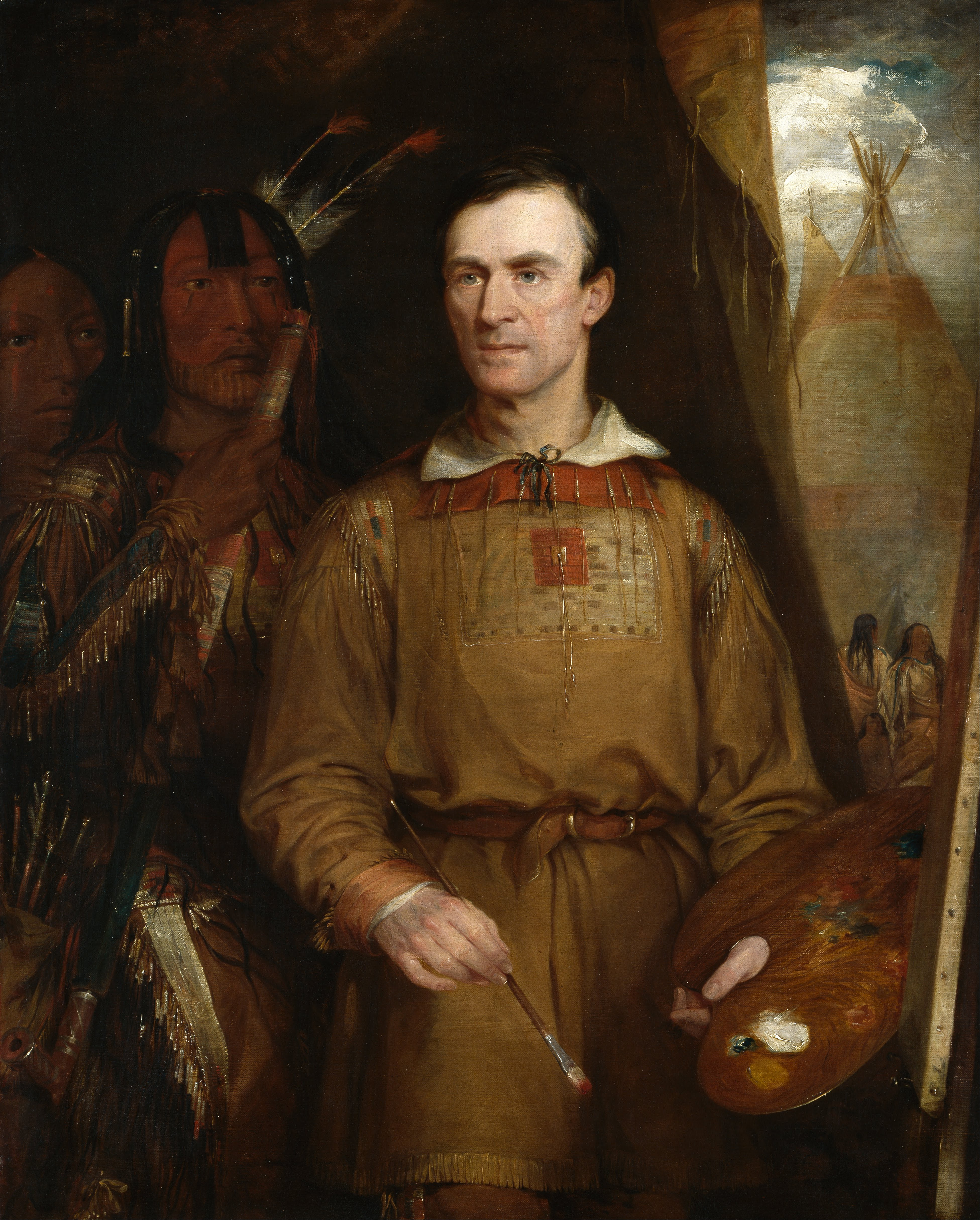
George Catlin
George Catlin was a self-taught American painter who devoted his career to documenting Native American peoples and their cultures across the Great Plains and Upper Missouri during the 1830s. He produced over 500 paintings of Native individuals and scenes from more than 50 tribes, many of the same peoples encountered by Lewis and Clark three decades earlier. His Indian Gallery remains one of the most significant visual records of pre-reservation Native American life in the West.
George Drouillard
George Drouillard was a French-Canadian and Shawnee métis frontiersman who served as the expedition's primary hunter, interpreter, and sign language specialist. Considered by many historians as the most valuable member of the Corps after Lewis and Clark themselves, Drouillard supplied more game meat than any other hunter and facilitated critical diplomatic encounters using Plains Indian sign language. Lewis described him as "a man of much merit" and relied on his wilderness expertise throughout the journey. He was killed by Blackfeet warriors in 1810 while trapping on the upper Missouri.
George Gibson
Private George Gibson was a skilled hunter and fiddle player who served in the Corps of Discovery. Along with Pierre Cruzatte, Gibson provided musical entertainment that boosted morale and helped establish friendly relations with Native peoples during the expedition. He was frequently selected for hunting parties and special assignments. Gibson suffered a serious fall from a horse during the return journey in 1806, which temporarily incapacitated him. He died in St. Louis in 1809, just a few years after the expedition's return.
George Shannon
Private George Shannon (1785–1836) was the youngest member of the permanent party of the Corps of Discovery at just 18 years old when the expedition departed. He became famously lost twice during the journey, once for 16 days along the Missouri when he got ahead of the main party and nearly starved. Despite his youth, Shannon proved an able soldier and was trusted with important assignments. After the expedition, he studied law and was wounded in a leg during the 1807 attempt to return Chief Sheheke to the Mandan, resulting in amputation. He went on to serve as a U.S. Senator from Missouri and helped Nicholas Biddle edit the expedition journals for publication.
George Washington

Henry Dearborn
Henry Dearborn (1751–1829) served as Secretary of War under President Thomas Jefferson during the planning and execution of the Lewis and Clark Expedition. In this capacity, he authorized the military personnel and supplies for the Corps of Discovery and facilitated Lewis's recruitment of soldiers from frontier Army posts. The Dearborn River in Montana was named in his honor by Lewis during the expedition.
Hugh Hall
Private Hugh Hall was a soldier from Pennsylvania who served in the Corps of Discovery. He was court-martialed along with John Collins early in the expedition for tapping into the whiskey supply without authorization. Hall was a reliable member of the Corps throughout the journey, participating in hunting parties and daily duties. Little is known of his life after the expedition, though he is believed to have settled in the St. Louis area.
Hugh McNeal
Private Hugh McNeal served in the Corps of Discovery and is remembered for several notable moments during the expedition. He accompanied Meriwether Lewis's advance party to Lemhi Pass in August 1805, where Lewis wrote that McNeal "stood with a foot on each side of this little rivulet and thanked his god that he had lived to bestride the mighty & heretofore deemed endless Missouri." He also had a dangerous encounter with a grizzly bear and narrowly escaped a potentially deadly situation in a Chinook village through the intervention of a friendly Native woman.
Jean Baptiste Charbonneau
Jean Baptiste Charbonneau, nicknamed "Pomp" or "Little Pomp" by William Clark, was born to Sacagawea and Toussaint Charbonneau at Fort Mandan on February 11, 1805, just two months before the expedition departed westward. He is the youngest known member of the Lewis and Clark Expedition, having been carried by his mother across the Rocky Mountains, down the Columbia River, and to the Pacific Ocean as an infant. After the expedition, William Clark took a personal interest in his education, and Jean Baptiste later traveled to Europe with Prince Paul of Württemberg, becoming fluent in English, French, German, and Spanish.
Jean Baptiste Lepage
Jean Baptiste Lepage was a French-Canadian fur trader who joined the Corps of Discovery at Fort Mandan in November 1804, replacing the discharged Private John Newman. He had previously traveled up the Missouri to trade with the Mandan and Hidatsa and was familiar with parts of the route ahead. Lepage served as a private for the remainder of the expedition and provided valuable knowledge of the upper Missouri region.
Jean Dodge
John Collins
Private John Collins was a member of the Corps of Discovery who was court-martialed early in the expedition for getting drunk on duty and tapping into the whiskey supply. Despite this early disciplinary issue, Collins became a dependable member of the expedition and was skilled at hunting and making beer from the camas root during the westward journey. He was frequently assigned to hunting parties and served reliably throughout the remainder of the expedition. Collins is believed to have been killed in the 1823 Arikara attack that also killed several members of William Ashley's fur trading party.
John Colter
John Colter was a private in the Corps of Discovery who became famous as one of the first mountain men and the first known person of European descent to enter what is now Yellowstone National Park. On the return journey in 1806, Lewis and Clark granted Colter an early discharge so he could join two fur trappers heading back up the Missouri. His subsequent solo explorations of the Yellowstone region — including geothermal features his contemporaries dubbed "Colter's Hell" — made him a legendary figure in the history of Western exploration. His famous escape from Blackfeet captivity, running naked across miles of rocky terrain, became one of the most celebrated frontier survival stories.
John Ordway
Sergeant John Ordway was one of the three sergeants who led squads within the Corps of Discovery and the only enlisted man to keep a journal for the entire duration of the expedition. His detailed daily entries provide an invaluable continuous record complementing the journals of Lewis and Clark. Ordway served as the de facto first sergeant, managing supplies, maintaining order, and commanding the camp when both Lewis and Clark were absent. After the expedition, he sold his journal to Lewis and Clark and settled in Missouri.
John Potts
Private John Potts was a German-born soldier from Pennsylvania who served in the Corps of Discovery. A capable and reliable member of the expedition, he was frequently assigned to hunting and scouting parties. Potts became a fur trapper after the expedition, partnering with fellow Corps veteran John Colter in the upper Missouri country. In 1808, while trapping on the Jefferson River near Three Forks, Potts and Colter were ambushed by Blackfeet warriors. Potts was killed in the confrontation, while Colter was stripped naked and forced to run for his life in the famous "Colter's Run."
John Shields
John Shields was the expedition's blacksmith and gunsmith, skills that proved invaluable throughout the journey. At Fort Mandan, Shields operated a forge where he repaired weapons and tools for both the Corps and the Mandan people, trading his blacksmithing services for corn and other provisions that sustained the expedition through the winter of 1804–1805. His ability to repair guns, forge metal tools, and fabricate replacement parts kept the expedition equipped and provided a crucial trade commodity with Native peoples who highly valued metalwork.
John Thompson
Private John B. Thompson was a surveyor from Indiana who served in the Corps of Discovery. He was a dependable member of the expedition who participated in various duties throughout the journey. Thompson was among those who voted on the winter campsite location at the Pacific coast. Little is known of his life after the expedition's return in September 1806.
Joseph Field
Joseph Field served alongside his brother Reubin as a private in the Corps of Discovery. A skilled woodsman and hunter from Kentucky, Joseph was part of Lewis's small party during the tense encounter with Blackfeet warriors on the Marias River in July 1806. He was frequently chosen for scouting missions and hunting parties, reflecting Lewis and Clark's trust in his frontier abilities. Joseph died just a year after the expedition's return, in 1807.
Joseph Gravelines
Joseph LaLiberte
Joseph Whitehouse
Private Joseph Whitehouse was one of the enlisted journal-keepers of the Lewis and Clark Expedition, producing a detailed account that provides perspectives sometimes missing from the officers' journals. His journal, discovered in the early 20th century, offers valuable observations about daily expedition life, encounters with Native peoples, and the landscape of the American West from the viewpoint of an ordinary soldier. Whitehouse was a tailor by trade and was responsible for making and repairing leather clothing and moccasins throughout the journey.
Kakawissassa (Crow at Rest)
Kakawissassa, known as Crow at Rest or Lightning Raven, was a chief of the Arikara who met with Lewis and Clark during the expedition's visit to the Arikara villages in October 1804. He was one of three principal Arikara chiefs who engaged in diplomatic councils with the expedition, as Lewis and Clark attempted to broker peace between the Arikara and their Mandan neighbors to the north.

Karl Bodmer
Karl Bodmer was a Swiss-born artist who accompanied Prince Maximilian of Wied-Neuwied on a scientific expedition up the Missouri River in 1832–1834, traveling through the same territory explored by Lewis and Clark. His meticulously detailed watercolors and engravings of Mandan, Hidatsa, and other Northern Plains tribes are considered among the finest artistic records of the American frontier.
Le Borgne (One Eye)
Le Borgne (One Eye) was the most powerful chief of the Hidatsa during the Lewis and Clark Expedition, leading the largest of the three Hidatsa villages near the Knife River. He was initially suspicious of the Americans and their intentions during the winter of 1804–1805, and Lewis and Clark worked carefully to maintain good relations with him. Le Borgne was a formidable warrior who had lost one eye in battle and wielded significant influence over both the Hidatsa and their Mandan neighbors.
Manuel Lisa
Manuel Lisa (1772–1820) was a Spanish-born fur trader based in St. Louis who became the most important American fur trade entrepreneur on the upper Missouri in the years immediately following the Lewis and Clark Expedition. He formed the Missouri Fur Company, employing several former Corps members including George Drouillard and John Colter, and established the first American trading post on the upper Missouri (Fort Raymond) in 1807. Lisa's commercial ventures built directly on the geographic knowledge and Native diplomatic contacts established by Lewis and Clark.
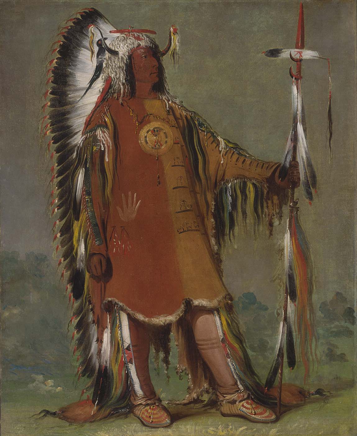
Mato-Tope (Four Bears)
Mato-Tope, or Four Bears (c. 1784–1837), was a renowned war chief of the Mandan people who became one of the most documented Native American leaders of the early 19th century. Although he was born after the Lewis and Clark Expedition passed through the Mandan villages in 1804–1805, Mato-Tope rose to prominence in the same communities that had provided crucial assistance to the Corps of Discovery during their winter at Fort Mandan. He was famously painted by both George Catlin in 1832 and Karl Bodmer in 1834, who produced the celebrated portrait "Mato-Tope, A Mandan Chief" depicting him in full ceremonial regalia. Known for his bravery in battle — including a legendary hand-to-hand combat with a Cheyenne chief — Mato-Tope was respected by both his people and the European and American visitors who documented Mandan culture. He died tragically during the devastating smallpox epidemic of 1837 that nearly annihilated the Mandan nation, reportedly delivering a powerful speech condemning the whites for bringing the disease before his death.
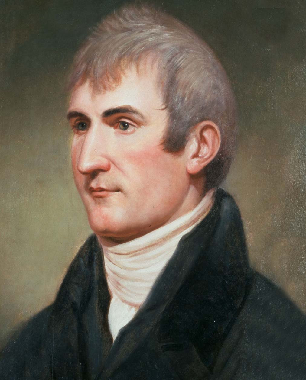
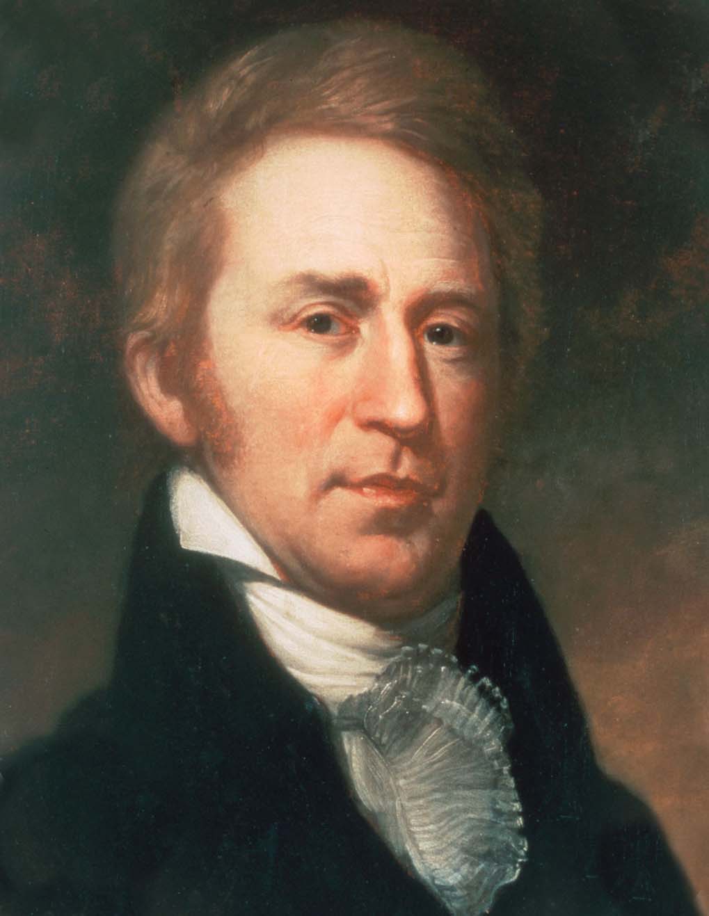
Meriwether Lewis
Meriwether Lewis (1774–1809) was an American explorer, soldier, and politician who served as the leader of the Lewis and Clark Expedition, also known as the Corps of Discovery, from 1804 to 1806. Appointed by President Thomas Jefferson as the expedition's commanding officer, Lewis was responsible for the scientific, diplomatic, and military objectives of the journey across the newly acquired Louisiana Territory to the Pacific Ocean. A skilled naturalist and keen observer, Lewis documented hundreds of plant and animal species previously unknown to Western science, maintained detailed journals of the expedition's encounters with Native American nations, and navigated the Corps through thousands of miles of uncharted wilderness. Before the expedition, Lewis served as Jefferson's private secretary at the White House, where the two planned the venture in detail. After returning as a national hero, Lewis was appointed Governor of Upper Louisiana Territory in 1807. He died under mysterious circumstances at Grinder's Stand, Tennessee, on October 11, 1809, at the age of 35 — his death remains one of American history's enduring mysteries, debated as either suicide or murder.
Napoleon Bonaparte
Nathan Kouns
Nathan Kouns was a frontier official who served as a witness and participant in treaty negotiations between the United States and Native American nations in the early 19th century. He was active in the Missouri and Mississippi river regions during the period of rapid American territorial expansion following the Louisiana Purchase.
Nathaniel Hale Pryor
See Nathaniel Pryor. This is an alternate reference using his full name, Nathaniel Hale Pryor (1772–1831), who served as one of three sergeants in the Corps of Discovery and later became a noted Indian agent among the Osage.
Nathaniel Pryor
Nathaniel Hale Pryor was one of the original three sergeants selected for the Corps of Discovery, a cousin of Sergeant Charles Floyd. He led a squad throughout the expedition and was entrusted with critical independent missions, including an attempt to return a Mandan chief to his people after the expedition. Pryor later served in the War of 1812 and became an Indian agent and trader among the Osage in present-day Oklahoma, where he married an Osage woman and was adopted into the nation.
Neeshnepahkeeook (Cut Nose)
Neeshnepahkeeook, known as Cut Nose, was a Nez Perce chief whose nose bore a distinctive scar from a lance wound. He met with Lewis and Clark during both their outbound and return passages through Nez Perce territory. Though there was some tension between Cut Nose and fellow chief Twisted Hair over the care of the expedition's horses during the winter, Cut Nose was generally helpful and played an important diplomatic role during the Corps' extended stay with the Nez Perce in 1806.
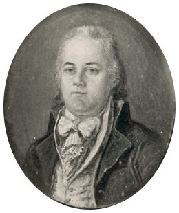
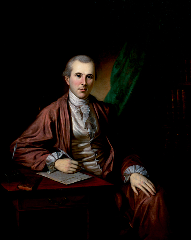
Nicholas Biddle
Nicholas Biddle was a Philadelphia lawyer, financier, and later president of the Second Bank of the United States who served as the editor of the first comprehensive published account of the Lewis and Clark Expedition. After Meriwether Lewis's death in 1809 left the expedition journals unpublished, William Clark entrusted the manuscripts to Biddle, who worked with journalist Paul Allen to produce the two-volume "History of the Expedition Under the Command of Captains Lewis and Clark" in 1814. This edition shaped public understanding of the expedition for generations.

Ninian Edwards
Ninian Edwards served as the first and only Governor of Illinois Territory from 1809 to 1818, and later as one of the first U.S. Senators from the state of Illinois. During the War of 1812, he led military campaigns against British-allied tribes in the upper Mississippi region.
As territorial governor, Edwards was a principal treaty commissioner responsible for negotiating numerous treaties with Indigenous nations in the Great Lakes and upper Mississippi region, including the Kickapoo, Potawatomi, Ottawa, and other nations. His treaty negotiations were instrumental in opening vast tracts of land in present-day Illinois and Wisconsin to American settlement.
Olaf Carl Seltzer
Olaf Carl Seltzer was a Danish-born American painter who arrived in Great Falls, Montana in 1897, where he became a protégé and close friend of Charles M. Russell. He produced over 2,500 paintings and illustrations of the American West, including detailed depictions of Lewis and Clark expedition scenes and encounters with Native peoples.
Old Toby
Old Toby was a Lemhi Shoshone elder who served as the expedition's guide over the treacherous Bitterroot Mountains and the Lolo Trail in September 1805, one of the most physically demanding segments of the entire journey. He was hired through Cameahwait and guided the Corps across Lemhi Pass and through the mountain wilderness. At one point Old Toby took a wrong turn that cost the expedition a day of travel. He left the expedition abruptly when they reached the Nez Perce villages, departing without collecting his pay — possibly because he was afraid of the Nez Perce or simply eager to return home before winter.

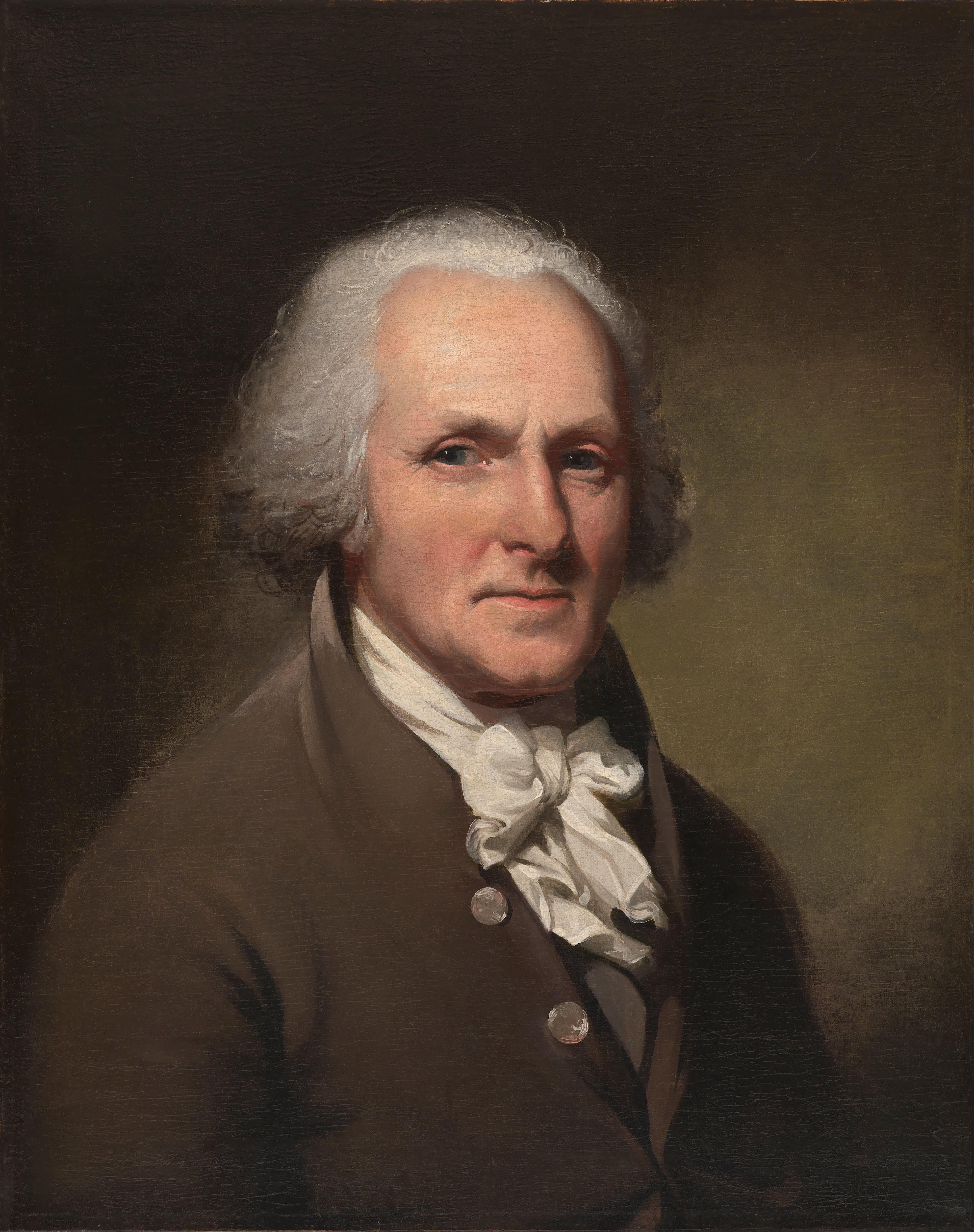
Patrick Gass
Patrick Gass was an Irish-born American soldier who served as a sergeant in the Corps of Discovery after being elected by his fellow soldiers to replace the deceased Sergeant Charles Floyd. An experienced carpenter, Gass supervised the construction of Fort Mandan and Fort Clatsop, the expedition's two winter quarters. His journal, published in 1807, was the first published account of the Lewis and Clark Expedition, appearing seven years before the official Biddle edition. Gass was the last surviving member of the expedition, dying in 1870 at the remarkable age of 99.
Paul Primeau
Pehriska-Ruhpa (Two Ravens)
Pehriska-Ruhpa, or Two Ravens, was a prominent Moennitarri (Hidatsa) warrior of the early 19th century, immortalized in Karl Bodmer's iconic 1834 painting "Pehriska-Ruhpa, Moennitarri Warrior in the Costume of the Dog Dance." The Hidatsa villages along the Knife River in present-day North Dakota were among the most important Native communities encountered by the Lewis and Clark Expedition, who spent the winter of 1804–1805 at nearby Fort Mandan. The Hidatsa provided the expedition with crucial geographical knowledge about the upper Missouri and the route to the Rocky Mountains. Pehriska-Ruhpa is depicted in elaborate ceremonial dress of the Dog Society, one of the Hidatsa military societies, including a distinctive feathered headdress and painted body. Bodmer created the portrait during Prince Maximilian of Wied-Neuwied's scientific expedition up the Missouri River in 1833–1834, which followed the same route Lewis and Clark had traveled three decades earlier.
Peter Weiser
Private Peter M. Weiser was a member of the Corps of Discovery from Pennsylvania. He proved a capable and reliable soldier throughout the expedition and was selected by Lewis for the advance party that made first contact with the Shoshone in August 1805. On the return journey, Weiser was part of Lewis's party exploring the Marias River. After the expedition, he became a fur trapper and trader, working for the Missouri Fur Company in the Snake River country of present-day Idaho, where the Weiser River was named in his honor.
Pierre Chouteau
Pierre Cruzatte
Pierre Cruzatte was a one-eyed French-Canadian boatman and fiddle player who served as the Corps of Discovery's principal waterman on the Missouri River and the expedition's musician. His expertise navigating the treacherous Missouri River currents was critical to the expedition's progress, and his fiddle playing provided entertainment and helped establish friendly relations with Native peoples during councils and celebrations. Cruzatte is also notable for accidentally shooting Meriwether Lewis in the buttock during a hunting excursion on August 11, 1806, near the end of the return journey.
Pierre Dorion Sr.
Pierre Dorion Sr. was a French-Canadian fur trader who had lived among the Yankton Sioux for over 20 years by the time Lewis and Clark ascended the Missouri in 1804. He served briefly as an interpreter during the expedition's council with the Yankton Sioux in August 1804, facilitating the important diplomatic meeting. Dorion was married to a Yankton woman and was well-respected among the Sioux. His son, Pierre Dorion Jr., later served as an interpreter for the Astorian expedition.
Posecopsahe (Black Cat)
Posecopsahe, known as Black Cat, was the principal chief of the Mandan village of Rooptahee (the upper village) and one of Lewis and Clark's most trusted Native allies during the winter of 1804–1805 at Fort Mandan. He visited the expedition's camp frequently, sharing intelligence about regional politics, geography, and the movements of neighboring nations. Clark described Black Cat as "Grand Chief of the Mandans" and considered him the most reliable and friendly of the Mandan leaders.
Reubin Field
Reubin Field, along with his brother Joseph, was among the first volunteers recruited for the Corps of Discovery. The Field brothers were skilled hunters and woodsmen from Kentucky who proved indispensable throughout the journey. Reubin was present at the violent encounter with Blackfeet warriors on July 27, 1806, during Lewis's exploration of the Marias River, where he killed one warrior in what was the expedition's only lethal confrontation with Native Americans. Lewis praised both brothers as "two of the most active and enterprising young men who accompanied us."
Richard Warfington
Corporal Richard Warfington commanded the return party that took the keelboat from Fort Mandan back to St. Louis in April 1805, carrying the expedition's first shipment of specimens, maps, journals, and reports to President Jefferson. This critical mission ensured that the scientific and diplomatic results of the first year of exploration were preserved even if the main party never returned. Warfington successfully delivered the cargo, including live prairie dogs and magpies, crates of botanical specimens, and detailed maps of the Missouri River.
Richard Windsor
Private Richard Windsor was a member of the Corps of Discovery who proved himself a reliable hunter and soldier throughout the expedition. He is particularly remembered for a harrowing near-death experience on a narrow cliff trail along the Missouri River, where he nearly fell to his death before Lewis talked him to safety. Windsor was frequently selected for hunting parties and scouting missions. Windsor Creek in Montana bears his name, bestowed by the captains during the expedition.
Robert Frazer
Private Robert Frazer served in the Corps of Discovery and kept a journal during the expedition, though it has never been found. He published a prospectus for his account in 1806, advertising a forthcoming book that never materialized. Frazer was among the members of the expedition who voted on the location of Fort Clatsop and participated in the full journey to the Pacific and back. His lost journal remains one of the tantalizing missing documents of American exploration history.
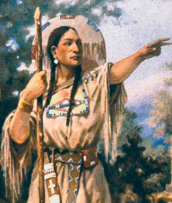
Sacagawea
Sacagawea (c. 1788–1812 or 1884) was a Lemhi Shoshone woman who accompanied the Lewis and Clark Expedition as an interpreter and guide from Fort Mandan in present-day North Dakota to the Pacific Ocean and back. Captured by a Hidatsa raiding party around age 12 and later purchased by French-Canadian fur trader Toussaint Charbonneau, she joined the expedition with her husband and their infant son, Jean Baptiste, who was born just two months before departure in February 1805. Sacagawea proved invaluable to the Corps of Discovery: her presence with an infant signaled peaceful intentions to the Native nations they encountered, she identified edible plants and geographical landmarks, and at a critical juncture she recognized the homeland of her own people, the Shoshone, facilitating the acquisition of horses essential for crossing the Rocky Mountains. Her emotional reunion with her brother Cameahwait, who had become chief of the Lemhi Shoshone, is one of the most celebrated moments of the expedition. Sacagawea is one of the most commemorated women in American history, with more statues dedicated to her than any other American woman.

Seaman
Seaman was a large Newfoundland dog purchased by Meriwether Lewis for $20 before the expedition departed. He accompanied the Corps of Discovery for the entire journey to the Pacific Ocean and back, serving as a hunter, guard dog, and companion. Lewis recorded multiple incidents involving Seaman in his journal, including the dog catching squirrels, being bitten by a beaver, and being stolen by Native Americans (who returned him after Lewis sent armed men). Seaman became such a curiosity to the Plains tribes that some offered to trade horses for him. He is one of the most celebrated animals in American exploration history.
Sergeant Charles Floyd
Sergeant Charles Floyd (1782–1804) was one of the original members of the Lewis and Clark Expedition and holds the somber distinction of being the only member of the Corps of Discovery to die during the journey. Floyd was one of three sergeants selected by Lewis and Clark to lead squads within the expedition, a testament to his leadership abilities and the trust placed in him by the commanding officers. He kept a journal during the early months of the expedition that provides valuable firsthand accounts of the journey up the Missouri River. On August 20, 1804, near present-day Sioux City, Iowa, Floyd died of what is now believed to have been a ruptured appendix — a condition that would have been fatal even with the best medical care available at the time. He was buried with full military honors on a bluff overlooking the Missouri River, and the site was later marked by a 100-foot stone obelisk, the Floyd Monument, which is the first registered National Historic Landmark in the United States. Remarkably, Floyd's death was the only fatality among the permanent party during the entire 8,000-mile, 28-month expedition.
Sheheke
Principal chief of Matootonha, the lower Mandan village, nicknamed "Big White" for his large size and fair complexion. He told the captains "If we eat you shall eat, if we starve you must starve also." He traveled to Washington to meet President Jefferson in 1807.
Silas Goodrich
Private Silas Goodrich was the Corps of Discovery's most accomplished fisherman, consistently providing fresh fish to supplement the expedition's diet of game meat. Lewis frequently praised Goodrich's skill in his journal entries, noting the various species he caught including cutthroat trout, which were new to science. Goodrich caught fish at nearly every major waterway the expedition encountered, from the Missouri to the Columbia. His catches contributed to the expedition's important ichthyological discoveries and scientific documentation of western fish species.
The Partisan
The Partisan (Tortohonga) was a Teton Sioux chief who confronted the Lewis and Clark Expedition at the mouth of the Bad River in September 1804 in what became the most dangerous diplomatic crisis of the entire journey. He demanded tribute for passage up the Missouri River and seized the bow cable of the expedition's pirogue, leading to a tense standoff where both sides prepared for armed conflict. The confrontation illustrated the complex power dynamics of the Missouri River corridor, where the Teton Sioux controlled trade access between upriver and downriver nations.
Thomas Howard
Private Thomas Proctor Howard was a member of the Corps of Discovery from Massachusetts. He was court-martialed during the expedition for climbing over the wall of Fort Mandan to enter the fort after being out past curfew, rather than using the gate. Howard served as a reliable member of the Corps throughout the full journey to the Pacific and back. After the expedition, he settled in the St. Louis area.

Thomas Jefferson
Thomas Jefferson, the third President of the United States, was the architect and primary sponsor of the Lewis and Clark Expedition. His lifelong fascination with the American West, combined with the strategic opportunity presented by the Louisiana Purchase of 1803, led him to commission the Corps of Discovery under the command of his private secretary, Meriwether Lewis. Jefferson drafted the detailed instructions for the expedition, emphasizing scientific observation, diplomatic relations with Native nations, and the search for a commercially viable route to the Pacific. He personally supervised Lewis's preparation, arranging training with leading scientists in Philadelphia. The expedition fulfilled Jefferson's vision of American expansion and scientific inquiry, though the hoped-for all-water route to the Pacific proved not to exist.
Thomas Mickell Burnham
Thomas Mickell Burnham was an American genre and portrait painter from Boston who produced "The Lewis and Clark Expedition" (1838), one of the earliest artistic depictions of the Corps of Discovery. His work capturing frontier life predated the more famous Western artists by decades.

Thomas Moran
Thomas Moran was a British-born American artist whose paintings of Yellowstone were instrumental in the creation of the first national park in 1872. He accompanied the Hayden Geological Survey to Yellowstone in 1871, painting the same geothermal wonders that Lewis and Clark expedition member John Colter had first reported in 1807.
Toussaint Charbonneau
Toussaint Charbonneau was a French-Canadian fur trader and interpreter who joined the Lewis and Clark Expedition at Fort Mandan in the winter of 1804–1805, along with his young Shoshone wife Sacagawea. Hired primarily for his ability to communicate with Hidatsa peoples, Charbonneau served as an interpreter throughout the journey to the Pacific and back. Though sometimes criticized by Lewis and Clark for his limited wilderness skills, Charbonneau proved valuable in facilitating communication with multiple Native nations encountered along the route.
Tunnachemootoolt (Broken Arm)
Tunnachemootoolt, known as Broken Arm, was a prominent Nez Perce chief who hosted the Lewis and Clark Expedition during their extended stay among the Nez Perce in May–June 1806 while waiting for the Bitterroot Mountain snows to melt. His village near present-day Kamiah, Idaho, served as the expedition's base camp, and he provided food, horses, and counsel about the mountain crossing. Broken Arm was one of the key Nez Perce leaders who helped ensure the expedition's safe passage through their territory.
Twisted Hair
Twisted Hair was an elderly Nez Perce chief who provided critical assistance to the Lewis and Clark Expedition in September 1805 after the Corps emerged starving and exhausted from their crossing of the Bitterroot Mountains via the Lolo Trail. He helped the expedition build dugout canoes for their descent of the Clearwater and Snake Rivers to the Columbia, drew maps of the route ahead, and agreed to care for the expedition's horses during the winter. His hospitality exemplified the generous reception the Corps received from the Nez Perce people.
Weucha
Weucha (also spelled Weuche), meaning "Shake Hand," was a chief of the Yankton Sioux who met with Lewis and Clark during the council near the mouth of the James River in August 1804. He was among the Yankton leaders who received medals and gifts from the expedition and helped establish the friendly tone of the diplomatic meeting. The Yankton council was one of the most successful of the expedition's many diplomatic encounters.
William Bratton
William Bratton served as a private and blacksmith in the Corps of Discovery. He suffered a severe back injury during the winter at Fort Clatsop that left him unable to walk for months, but was eventually cured through a sweat lodge treatment suggested by the Nez Perce. Bratton assisted John Shields at the forge and was a skilled hunter. After the expedition, he served in the War of 1812 under William Clark and later settled in Indiana.
William Clark
William Clark was an American explorer, soldier, and territorial official who co-led the Lewis and Clark Expedition (1804–1806) across the western United States to the Pacific Ocean. After the expedition, Clark was appointed Brigadier General of militia for Louisiana Territory and served as Superintendent of Indian Affairs at St. Louis from 1807 until his death.
As Superintendent, Clark was the principal U.S. negotiator for dozens of treaties with Native American nations in the trans-Mississippi region. He negotiated or witnessed more treaties than any other individual in this collection, playing a central role in the diplomatic framework that shaped relations between the United States and Indigenous peoples of the Missouri and Mississippi river valleys during the early 19th century.
William Werner
Private William Werner served as one of the Corps of Discovery's cooks and was a dependable member of the expedition throughout the entire journey. He was court-martialed once for disobedience but otherwise served without notable incident. Werner participated in the full journey from Camp Dubois to the Pacific Ocean and back. Little is recorded about his life after the expedition's return to St. Louis in September 1806.
Yelleppit
Yelleppit was the principal chief of the Walla Walla people who met the Lewis and Clark Expedition along the Columbia River. He was notably welcoming, providing food, horses, and assistance during both the outbound and return journeys. During the return trip in April 1806, Yelleppit hosted a grand feast and dance, providing canoes for the river crossing and horses for the overland journey — generosity that deeply impressed Clark, who gave the chief his sword and a quantity of ammunition.

York
York (c. 1770–unknown) was an enslaved African American man owned by William Clark who served as a full working member of the Lewis and Clark Expedition from 1804 to 1806. York was the first African American to cross the continent north of Mexico and participate in an exploration of this magnitude. Throughout the journey, York performed the same duties as other Corps members — hunting, portaging, scouting, and voting on key decisions, including the choice of winter camp at Fort Clatsop. He was a source of great fascination to many Native American nations encountered along the route, particularly the Mandan and Arikara, who had never seen a Black man before. Despite his essential contributions to the expedition's success, York was not granted his freedom upon return. He repeatedly petitioned Clark for his liberty in the years that followed; historical accounts differ on when or whether he was eventually freed. York's story represents both the remarkable achievements and the deep contradictions of the early American republic.
Nations & Tribes (54)
Arikara
The Arikara (also called Ree) were a Caddoan-speaking, semi-sedentary agricultural people who lived in fortified earth-lodge villages along the Missouri River in present-day South Dakota. By the time Lewis and Clark arrived in October 1804, the Arikara had been devastated by successive smallpox epidemics that reduced their numbers from perhaps 30,000 to a few thousand, consolidating from as many as 30 villages down to three. The expedition spent several days among the Arikara, finding them hospitable traders who cultivated corn, beans, squash, and tobacco and maintained complex trade relationships with neighboring nomadic nations, particularly the Sioux. The Arikara chief Too Ne expressed willingness to pursue peace with the Mandan at the expedition's urging, though intertribal tensions persisted long after the Corps departed.
Assiniboine
The Assiniboine (Nakoda) were a Siouan-speaking people who had separated from the Yanktonai Sioux centuries earlier and occupied a vast territory across the northern Great Plains, ranging from present-day Montana into Saskatchewan and Manitoba. Lewis and Clark did not encounter the Assiniboine directly during the main journey, but learned of them extensively during the winter of 1804–1805 at Fort Mandan, where the Mandan and Hidatsa described them as important trading partners and occasional adversaries. The Assiniboine were prominent participants in the extensive northern Plains trade network, exchanging European goods obtained from British posts on the Assiniboine River for corn and horses from the village tribes.
Blackfeet
The Blackfeet Confederacy (Niitsitapi), comprising the Piegan (Piikani), Blood (Kainai), and Siksika bands, dominated the northwestern Great Plains from the Saskatchewan River south into present-day Montana, controlling a territory rich in bison. The expedition's only violent encounter with any Native nation occurred on July 26–27, 1806, when Meriwether Lewis and a small party met a group of Piegan Blackfeet along the Two Medicine River; a confrontation over stolen horses and guns resulted in the deaths of two Blackfeet warriors, the only Native fatalities of the entire expedition. Lewis and Clark had learned of the Blackfeet's formidable military reputation during the winter at Fort Mandan, where the Hidatsa described them as aggressive enemies who blocked western tribes from accessing guns and trade goods. This incident inaugurated decades of Blackfeet hostility toward American traders and trappers entering their territory.
Cayuse
The Cayuse were a small but influential nation who inhabited the plateaus and river valleys of the Blue Mountains region in present-day northeastern Oregon and southeastern Washington. Though Sahaptian in cultural affiliation, they spoke a language isolate (Cayuse) and were renowned horsemen who had amassed large herds, making them powerful participants in regional trade and warfare. The Corps of Discovery passed through Cayuse territory in October 1805 on the outbound journey and again in the spring of 1806 on the return, though direct interactions were limited compared to their more extensive contact with neighboring Nez Perce and Walla Walla peoples.
Chinook
The Chinook proper (Lower Chinook) lived along the north bank of the Columbia River near its mouth and on the shores of present-day Willapa Bay in Washington, occupying one of the most resource-rich environments on the continent. They were the preeminent traders of the Pacific Northwest, and the Chinook trade jargon that bore their name served as the lingua franca of commerce from Alaska to California. Lewis and Clark encountered the Chinook in November 1805, finding them skilled canoe builders and shrewd negotiators already experienced in dealing with Euro-American maritime traders. The expedition noted their flattened-head cranial modification, elaborate cedar plank houses, and extensive use of salmon and wapato.

Chipawa Tribe
"Chipawa" is a historical variant spelling of Chippewa (Ojibwe/Anishinaabe) found in early American treaty documents. This alternate orthography reflects the varied transcription practices of 18th and 19th-century treaty scribes. The Chipawa referenced in these treaties are the same Anishinaabe people described under the Chippewa designation.
Chippewa Tribe
The Chippewa, or Ojibwe (Anishinaabe), are one of the largest Indigenous nations in North America, with traditional territories spanning the Great Lakes region from present-day Ontario and Quebec through Michigan, Wisconsin, and Minnesota. They are part of the broader Anishinaabe confederacy, which includes the Ottawa and Potawatomi in the Council of Three Fires.
The Ojibwe entered into numerous treaties with the United States throughout the 19th century, ceding vast territories in the upper Midwest while retaining important reserved rights to fishing, hunting, and gathering. They remain one of the most populous Native American nations, with communities across the U.S. and Canada.
Clatsop
The Clatsop were a Chinookan-speaking people who lived on the south side of the Columbia River estuary and along the northern Oregon coast, in the vicinity of present-day Astoria. The Corps of Discovery established Fort Clatsop in December 1805 in their territory, naming the winter encampment after them, and maintained close relations with the Clatsop throughout the wet, difficult winter of 1805–1806. The Clatsop provided valuable geographic information, traded food (particularly fish, berries, and roots), and alerted the expedition to a beached whale on the coast. Like other Lower Chinookan peoples, the Clatsop practiced cranial modification, lived in cedar longhouses, and depended heavily on salmon, though their population was already declining from exposure to diseases introduced by European and American maritime traders.
Coeur d'Alene
The Coeur d'Alene (Schitsu'umsh) occupied the lake, river, and forest country of present-day northern Idaho, centered around the lake that bears their name. Lewis and Clark did not directly encounter the Coeur d'Alene during the expedition, but they passed near the southern margins of their territory during the arduous Lolo Trail crossing of the Bitterroot Mountains and gathered information about them from neighboring peoples, particularly the Nez Perce. The Coeur d'Alene were an Interior Salish-speaking people whose subsistence combined fishing, gathering camas and other roots, and hunting, and they were active participants in the Plateau trade network.
Crow (Apsaalooke)
The Crow (Apsaalooke) were a Siouan-speaking people who occupied the Yellowstone River valley and its tributaries in present-day southern Montana and northern Wyoming, a territory they had settled after separating from the Hidatsa. Lewis and Clark did not meet the Crow directly during the expedition, but learned of them extensively from the Hidatsa at Fort Mandan, who described them as relatives-turned-rivals and formidable horsemen controlling prime bison hunting territory. William Clark passed through the margins of Crow territory during his 1806 return journey down the Yellowstone River, finding signs of their presence but making no direct contact. The Crow were noted for their exceptionally long hair, skilled horsemanship, large horse herds, and elaborate material culture.

Delaware Nation
The Delaware, or Lenape, are an Algonquian-speaking people whose ancestral homeland encompassed the Delaware River valley, portions of present-day New Jersey, Pennsylvania, New York, and Delaware. Known as the "Grandfathers" of the Algonquian nations, the Lenape were progressively displaced westward through a long series of treaties and removals beginning in the colonial era.
By the early 19th century, significant Lenape communities had relocated to Ohio, Indiana, and Missouri, where they entered into treaties with the United States regarding their western lands. Today, the Delaware Nation and Delaware Tribe of Indians are headquartered in Oklahoma.
Flathead Salish
The Flathead Salish (Bitterroot Salish, or Selis) lived in the Bitterroot Valley of present-day western Montana and ranged eastward onto the Plains for seasonal bison hunts. The Corps of Discovery encountered them in September 1805 at a place they called "Ross's Hole" (near present-day Sula, Montana), finding approximately 400 Salish with a large horse herd; the expedition traded for fresh horses desperately needed for the Bitterroot crossing. Despite their English name "Flathead," the Salish did not practice cranial modification—the misnomer likely arose from sign-language confusion or from neighboring tribes' descriptions. The Salish were generous hosts who shared food and horses, and their encounter with Lewis and Clark was entirely peaceful.

Grand Pawnee
The Grand Pawnee, or Chaui, were the leading band of the Pawnee confederation, residing primarily along the Platte River in present-day Nebraska. As the most prominent Pawnee band, the Chaui chiefs often served as principal negotiators in diplomatic engagements with European and American powers.
The Grand Pawnee entered into treaties with the United States as part of early 19th-century diplomatic efforts to establish peace and trade relations with the nations of the central Plains.
Hidatsa
The Hidatsa (also called Minitari or Gros Ventres of the Missouri) were a Siouan-speaking agricultural people who lived in three earth-lodge villages near the confluence of the Knife and Missouri Rivers in present-day North Dakota, adjacent to the Mandan. The expedition spent the winter of 1804–1805 at Fort Mandan in close proximity to the Hidatsa, gathering an enormous quantity of geographic, ethnographic, and strategic intelligence from them about the territory to the west. It was in a Hidatsa village that the expedition hired Toussaint Charbonneau and, crucially, encountered his wife Sacagawea, a Lemhi Shoshone woman who had been captured by the Hidatsa in a raid years earlier. The Hidatsa were skilled farmers, warriors, and traders whose detailed knowledge of the upper Missouri and Rocky Mountain geography proved essential to the expedition's route planning.

Iowa Tribe
The Iowa, or Báxoje (Ioway), are a Chiwere Siouan-speaking people whose ancestral territory extended across present-day Iowa, Missouri, Minnesota, and Wisconsin. They were closely related to the Otoe and Missouria nations and lived primarily along the rivers of the upper Missouri drainage.
The Iowa entered into multiple treaties with the United States in the early 19th century, including agreements at Portage des Sioux in 1815. These treaties established peace following the War of 1812 and progressively ceded Ioway lands. Today, the Iowa Tribe is divided between the Iowa Tribe of Oklahoma and the Iowa Tribe of Kansas and Nebraska.
Kathlamet
The Kathlamet were a small Chinookan-speaking people who lived along the Columbia River in the vicinity of present-day Cathlamet, Washington, and the marshy islands of the lower Columbia estuary. Lewis and Clark encountered them in November 1805 during the descent of the Columbia and again on the return journey in March 1806, noting their villages, canoes, and trade goods. Like other Lower Chinookan peoples, the Kathlamet were deeply embedded in the Columbia River trade network, practiced cranial modification, and subsisted primarily on salmon, wapato root, and other riverine resources.

Kaw Nation
The Kaw, or Kanza (the people for whom the state of Kansas is named), are a Dhegihan Siouan-speaking nation closely related to the Osage, Ponca, Omaha, and Quapaw. Their homeland was centered on the Kansas River valley and portions of the Missouri River in present-day northeastern Kansas.
The Kaw entered into treaties with the United States that progressively reduced their territory throughout the 19th century. Today, the Kaw Nation is headquartered in Kaw City, Oklahoma, and counts among its notable members Charles Curtis, the 31st Vice President of the United States.

Kickapoo Tribe
The Kickapoo (Kiikaapoi) are an Algonquian-speaking people whose original territory lay in the Great Lakes region of present-day Wisconsin and Illinois. Known as fierce warriors and skilled diplomats, the Kickapoo maintained their independence through strategic alliances and military resistance to American expansion.
The Kickapoo signed treaties with the United States in the early 19th century that ceded portions of their Illinois homeland. Notably resistant to removal, different Kickapoo bands migrated to Kansas, Oklahoma, Texas, and Mexico, where communities persist today.
Lemhi Shoshone
The Lemhi Shoshone (Agaidika, or "Salmon Eaters") inhabited the Lemhi River valley and surrounding mountains in present-day east-central Idaho, occupying a critical geographic position at the Continental Divide. Their encounter with the expedition in August 1805 was one of the most consequential of the entire journey: Chief Cameahwait, who turned out to be Sacagawea's brother, agreed to provide horses and guides essential for the expedition's crossing of the Bitterroot Mountains. Lewis and Clark found the Lemhi Shoshone lacking guns and metal goods but rich in geographic knowledge and horsemanship, and desperately eager to obtain firearms to defend themselves against Blackfeet and Hidatsa raiding parties. The reunion between Sacagawea and her people remains one of the most dramatic episodes in the expedition's narrative.
Makah Tribe
The Makah (Kwih-dich-chuh-ahtx, "People of the Cape") are a Wakashan-speaking people of the northwestern tip of the Olympic Peninsula in present-day Washington State. They are the only Wakashan-speaking tribe in the contiguous United States and are renowned as skilled maritime hunters and fishers.
The Makah's inclusion in Lewis and Clark era treaty records reflects the broad scope of American diplomatic engagement with Indigenous nations across the continent during the early 19th century. The Makah Tribe is headquartered at Neah Bay, Washington.
Mandan
The Mandan were a Siouan-speaking people who lived in fortified earth-lodge villages along the Missouri River in present-day central North Dakota, and they served as the epicenter of a vast intertribal trade network linking the northern Plains, Rocky Mountains, and Great Lakes. Lewis and Clark arrived at the Mandan villages in late October 1804 and built Fort Mandan nearby, spending the winter of 1804–1805 in what became the expedition's longest and most productive encampment. The Mandan were gracious hosts, sophisticated diplomats, and experienced traders whose knowledge of regional geography, intertribal politics, and western territories was indispensable to the expedition's planning. Their agricultural economy—centered on corn, beans, squash, and sunflowers—supported a complex ceremonial life including the Okipa ceremony, though their population had been catastrophically reduced by smallpox in 1781 and would be nearly annihilated by the epidemic of 1837.

Menominee Nation
The Menominee (Mamaceqtaw, "Wild Rice People") are an Algonquian-speaking nation whose homeland centers on the forests and waterways of present-day Wisconsin and upper Michigan. They are among the oldest continuous residents of any region in North America, with archaeological evidence of Menominee presence in Wisconsin spanning thousands of years.
The Menominee entered into treaties with the United States that ceded much of their territory while establishing the Menominee Reservation in northeastern Wisconsin, where the Menominee Indian Tribe of Wisconsin is headquartered today.
Multnomah
The Multnomah were a Chinookan-speaking people who inhabited the area around the confluence of the Willamette and Columbia Rivers, including Sauvie Island and the Portland Basin of present-day Oregon. Clark explored the lower Willamette River in April 1806 on the return journey and documented large Multnomah villages, noting their substantial cedar plank houses, extensive use of wapato root, and active participation in Columbia River trade. The term "Multnomah" as used by Lewis and Clark likely encompassed several related Chinookan bands in the Portland Basin area. Like other Chinookan peoples of the lower Columbia, the Multnomah were devastated by disease in the decades following contact.
Nez Perce
The Nez Perce (Nimiipuu) occupied a large territory encompassing the Clearwater, Salmon, and Snake River drainages in present-day central Idaho, southeastern Washington, and northeastern Oregon. The expedition encountered the Nez Perce in September 1805, arriving in their territory starving and exhausted after the harrowing Bitterroot crossing; the Nez Perce, led by chiefs including Twisted Hair and Cut Nose, provided food, shelter, and canoe-building assistance that almost certainly saved the expedition from disaster. The Corps left their horse herd in Nez Perce care for the winter, retrieving them on the return journey in spring 1806, during which they spent nearly a month among the Nez Perce waiting for snow to melt on the Lolo Trail. The Nez Perce were master horse breeders, skilled fishermen, and camas gatherers whose hospitality and practical assistance rank among the most significant Native contributions to the expedition's survival.

Noisy Pawnee
The Noisy Pawnee, or Pitahawirata (also known as Tappage), were one of the four bands of the Pawnee confederation, living along the tributaries of the Platte River in present-day Nebraska. The name "Noisy" or "Tappage" likely referred to the band's reputation in intertribal and diplomatic contexts.
As a constituent band of the Pawnee Nation, the Pitahawirata participated in treaty negotiations with the United States during the early territorial period of the trans-Missouri West.
Omaha
The Omaha (Umonhon) were a Siouan-speaking people who inhabited the eastern Nebraska prairies along the Missouri River, with their principal village near present-day Homer, Nebraska. Lewis and Clark sought to meet the Omaha in August 1804 but found their village largely deserted, as the nation was away on a bison hunt; the captains learned that the Omaha had recently been devastated by a smallpox epidemic that killed perhaps 400 people, including their chief Blackbird, who had been buried sitting upright on a bluff overlooking the Missouri. The Omaha were historically powerful traders who controlled commerce along the middle Missouri, but by 1804 they were weakened by disease and under pressure from the expanding Teton Sioux.

Osage Nation
The Osage Nation (Wazhazhe) is a Dhegihan Siouan-speaking people whose traditional homeland encompassed present-day Missouri, Arkansas, Kansas, and Oklahoma. They were one of the most powerful nations in the central Plains and maintained extensive trade relationships with French and later American traders, including the Chouteau family.
The Osage signed several significant treaties with the United States beginning with the Treaty of Fort Clark in 1808, which ceded much of their territory in present-day Missouri and Arkansas. These treaties fundamentally altered Osage territorial boundaries and laid the groundwork for their eventual removal to Indian Territory (Oklahoma), where the Osage Nation is headquartered today in Pawhuska.

Oto Tribe
The Otoe (Jiwere) are a Chiwere Siouan-speaking people closely related to the Iowa and Missouria nations. Their traditional territory was located along the Missouri River in present-day Nebraska and Missouri. The Otoe were the first Indigenous nation to hold a formal council with the Lewis and Clark Expedition, meeting near present-day Council Bluffs, Iowa, in August 1804.
The Otoe entered into several treaties with the United States in the early 19th century. Today, the Otoe-Missouria Tribe is headquartered in Red Rock, Oklahoma.
Otoe-Missouria
The Otoe and Missouria were closely related Siouan-speaking peoples who, by 1804, had merged into a combined nation living along the lower Platte and Missouri Rivers in present-day southeastern Nebraska. On August 3, 1804, at a site the captains named "Council Bluffs" (near present-day Fort Calhoun, Nebraska), Lewis and Clark held their first formal council with any western Native nation, meeting with Otoe-Missouria leaders including Chief Little Thief and Big Horse. The captains delivered their standard diplomatic message—announcing American sovereignty following the Louisiana Purchase, urging intertribal peace, and distributing medals, flags, and gifts—establishing the template they would use throughout the journey.

Ottawa Tribe
The Ottawa, or Odawa, are an Anishinaabe people of the Great Lakes region, closely related to the Ojibwe and Potawatomi through the Council of Three Fires alliance. Their traditional territories encompassed the shores of Lakes Huron and Michigan and the waterways of present-day Michigan and Ontario. They were renowned as intertribal traders and middlemen in the Great Lakes fur trade.
The Ottawa entered into treaties with the United States in the early 19th century regarding their Great Lakes territories. Today, several Ottawa tribal governments exist in Michigan and Oklahoma.
Palouse
The Palouse (Palus) were a Sahaptian-speaking people who lived along the Snake and Palouse Rivers in present-day southeastern Washington, occupying the arid steppe country that bears their name. Lewis and Clark encountered the Palouse in October 1805 at the confluence of the Palouse and Snake Rivers during the downstream journey, noting their mat lodges, dried salmon stores, and horse herds. The Palouse were closely related culturally and linguistically to the Nez Perce and Yakama, sharing the Plateau cultural pattern of seasonal rounds combining salmon fishing, root gathering, and hunting.

Pawnee Marhar
The Pawnee Marhar (also rendered as Pawnee Maha) appears in early 19th-century treaty records as a distinct group associated with the broader Pawnee confederation of the central Great Plains. The designation may refer to a specific band or village group within the Pawnee political structure.
They participated in treaty negotiations with the United States during the period of American expansion into the Missouri River region following the Louisiana Purchase.

Pawnee Nation
The Pawnee (Chaticks si Chaticks, "Men of Men") are a Caddoan-speaking people whose homeland was centered on the Platte and Loup river valleys of present-day Nebraska. They were a semi-sedentary nation known for their distinctive earth lodge villages, sophisticated astronomical knowledge, and seasonal buffalo hunts.
The Pawnee comprised four bands: the Chaui (Grand), Kitkahahki (Republican), Pitahawirata (Tappage), and Skidi (Loup/Wolf). They maintained generally peaceful relations with the United States and signed several treaties in the early 19th century. The Pawnee Nation is headquartered today in Pawnee, Oklahoma.
Piankashaw
The Piankashaw (Peanguichia) were a band of the Miami-Illinois confederacy whose homeland was centered on the lower Wabash River valley in present-day Indiana and Illinois. They were closely allied with the Wea and Miami nations and spoke a dialect of the Miami-Illinois Algonquian language.
The Piankashaw entered into treaties with the United States that ceded their lands in the Wabash region. They were later consolidated with other Miami-related bands and eventually removed to Indian Territory (Oklahoma), where their descendants are enrolled in the Peoria Tribe of Indians of Oklahoma.

Ponca Tribe
The Ponca (Ponka) are a Dhegihan Siouan-speaking people closely related to the Omaha, Osage, Kaw, and Quapaw nations. Their homeland was located at the confluence of the Niobrara and Missouri rivers in present-day northeastern Nebraska. The Lewis and Clark Expedition passed through Ponca territory in 1804.
The Ponca entered into treaties with the United States and were later forcibly removed to Indian Territory in 1877, an event that sparked the landmark Standing Bear v. Crook case (1879), which established that Native Americans are "persons" under the law. Today, the Ponca maintain tribal governments in both Nebraska and Oklahoma.

Potawatomi Nation
The Potawatomi (Bodewadmi, "Keepers of the Fire") are an Anishinaabe people of the Great Lakes region and members of the Council of Three Fires alongside the Ojibwe and Ottawa. Their traditional territory encompassed areas of present-day Michigan, Indiana, Illinois, and Wisconsin.
The Potawatomi signed numerous treaties with the United States that progressively ceded their Great Lakes homelands. Their removal westward in the 1830s, known as the Potawatomi Trail of Death, displaced thousands to Kansas and Indian Territory. Today, several Potawatomi tribal nations exist across the U.S., including the Citizen Potawatomi Nation in Oklahoma.
Potawatomi Tribe/Nation
This entry represents additional treaty references to the Potawatomi (Bodewadmi) Nation under a variant designation in historical records. The Potawatomi were signatories to numerous treaties with the United States involving their Great Lakes and upper Mississippi territories. See also: Potawatomi Nation.
Quapaw Nation
The Quapaw (Ogaxpa, "Downstream People") are a Dhegihan Siouan-speaking people whose homeland was at the confluence of the Arkansas and Mississippi rivers in present-day southeastern Arkansas. They are linguistically and culturally related to the Osage, Ponca, Omaha, and Kaw nations.
The Quapaw entered into treaties with the United States that ceded their extensive Arkansas territories in the 1810s and 1820s. Today, the Quapaw Nation is headquartered in Quapaw, Oklahoma, and is known for its lead and zinc mining operations and cultural preservation efforts.

Sac and Fox Nation
The Sac (Sauk) and Meskwaki (Fox) are two closely allied Algonquian-speaking nations whose combined territory spanned the upper Mississippi River valley, including present-day Wisconsin, Illinois, Iowa, and Missouri. Though distinct peoples, they formed a powerful confederation through intermarriage and military alliance.
The Sac and Fox signed numerous treaties with the United States, beginning with the controversial 1804 Treaty of St. Louis, which the nations later disputed as unauthorized. These treaties ceded vast territories in the upper Midwest and ultimately led to the Black Hawk War of 1832. Today, the Sac and Fox maintain tribal governments in Oklahoma, Iowa, and Kansas-Nebraska.

Shawnee Tribe
The Shawnee (Shaawanwa) are a Central Algonquian-speaking people whose territory historically encompassed the Ohio River valley and portions of present-day Ohio, Kentucky, West Virginia, and Pennsylvania. They were renowned as warriors and diplomats and played a central role in resistance to American expansion under leaders such as Tecumseh.
The Shawnee entered into multiple treaties with the United States as they were progressively displaced from the Ohio Valley westward. Today, three federally recognized Shawnee tribes exist: the Shawnee Tribe, Eastern Shawnee Tribe of Oklahoma, and Absentee-Shawnee Tribe of Indians of Oklahoma.
Shoshone
The broader Shoshone nation encompassed multiple groups of Numic-speaking peoples spread across a vast territory from the Rocky Mountains to the Great Basin, including the Wind River Shoshone (Eastern) and various Northern Shoshone bands in present-day Idaho, Wyoming, and Montana. Lewis and Clark's planning relied heavily on the expectation that the Shoshone would possess the horses needed to cross the Continental Divide, a calculation that proved correct when they reached the Lemhi band in August 1805. The Shoshone had once ranged freely onto the northern Plains for bison hunting but had been pushed westward into the mountains by Blackfeet and Hidatsa raiders who possessed firearms obtained through the Canadian fur trade. The expedition's journals document Shoshone material culture, subsistence strategies in a challenging mountain environment, and the acute military disadvantage faced by peoples without access to Euro-American weaponry.

Sioux of St. Peter’s River
The Sioux of St. Peter’s River refers to the Dakota Sioux bands, primarily the Mdewakanton and Wahpekute, who lived along the Minnesota River (historically called the St. Peter’s River) in present-day southern Minnesota. These eastern Dakota communities were among the first Siouan peoples to engage in sustained diplomatic contact with the United States.nnThey entered into treaties at Portage des Sioux and other locations in the 1810s and 1820s as part of broader U.S. efforts to establish peace and trade agreements with the various Sioux bands following the War of 1812.
Sioux of the Lakes
The Sioux of the Lakes refers to the western Dakota bands—primarily the Sisseton and Wahpeton—who inhabited the lake and prairie country of present-day western Minnesota and eastern South Dakota. They occupied the headwaters region of the Minnesota and Des Moines rivers and the lake country stretching to the Coteau des Prairies.
These bands engaged in treaty negotiations with the United States as part of the post-War of 1812 peace settlements, agreeing to terms that established formal diplomatic relations and trade frameworks with the American government.

Sioux Tribe/Nation
The Sioux, or Oceti Sakowin (Seven Council Fires), are a large confederation of Siouan-speaking peoples whose territory spanned the Northern Great Plains from Minnesota to the Rocky Mountains. The confederation includes three major divisions: the Dakota (Santee), Nakota (Yankton-Yanktonai), and Lakota (Teton).
The Sioux were among the most significant Indigenous powers encountered during and after the Lewis and Clark Expedition, with the Teton Lakota famously confronting the expedition at the confluence of the Bad and Missouri rivers in 1804. Multiple Sioux bands entered into treaties with the United States at Portage des Sioux and other locations in the 1810s–1820s.
Teton Sioux (Lakota)
The Teton Sioux (Lakota) were the westernmost and most powerful division of the great Sioux (Oceti Sakowin) nation, dominating the central Great Plains from the Missouri River westward to the Black Hills and beyond in present-day South Dakota. The confrontation between the expedition and the Teton Sioux near the mouth of the Bad River in late September 1804 was the most dangerous diplomatic crisis of the entire journey; chiefs Black Buffalo, the Partisan, and Buffalo Medicine tested the expedition's resolve in a tense standoff that nearly erupted into armed conflict. The Lakota controlled Missouri River commerce through a system of tolls and trade dominance that Lewis and Clark were determined to break as part of American strategic interests, creating a fundamental conflict of purpose. The Teton Sioux were at the height of their power in 1804—superb equestrian bison hunters, formidable warriors, and skilled diplomats.

Teton Tribe
The Teton, or Lakota, are the westernmost and largest division of the Oceti Sakowin (Great Sioux Nation), comprising seven bands including the Oglala, Brulé, Hunkpapa, and Miniconjou. Their territory encompassed the western Great Plains from the Missouri River to the Black Hills and beyond.
The Teton Lakota had one of the most significant encounters with the Lewis and Clark Expedition in September 1804, when a tense standoff occurred near the mouth of the Bad River. They entered into subsequent treaties with the United States, though they remained one of the most independent and militarily powerful nations on the Northern Plains throughout the 19th century.
Tillamook
The Tillamook were a Coast Salish-speaking people—the southernmost Salishan group on the Pacific Coast—who inhabited the coastal bays, estuaries, and rainforests of present-day Tillamook County, Oregon. Members of the expedition encountered the Tillamook in January 1806, when Clark led a party south from Fort Clatsop to obtain blubber and oil from a whale that had washed ashore near present-day Cannon Beach. The Tillamook had already processed much of the whale by the time Clark's party arrived, and they proved to be firm but fair traders, exchanging whale blubber and oil for trade goods. The Tillamook shared the broader Northwest Coast cultural pattern of cedar plank houses, canoe-based maritime subsistence, and elaborate social stratification.
Umatilla
The Umatilla were a Sahaptian-speaking people who lived along the Columbia River and its tributaries, particularly the Umatilla River, in present-day northeastern Oregon. Lewis and Clark passed through Umatilla territory in October 1805 and again in April 1806, observing their riverside villages, extensive fishing operations at seasonal salmon runs, and their role in the regional trade network. The Umatilla shared the Plateau cultural pattern of seasonal rounds—fishing for salmon in spring and fall, gathering camas and other roots in summer, and hunting in the uplands—and maintained close relationships with the neighboring Cayuse and Walla Walla peoples.
Walla Walla
The Walla Walla (Wallulapum) were a Sahaptian-speaking people who inhabited the confluence region of the Snake, Columbia, and Walla Walla Rivers in present-day southeastern Washington. Their chief, Yelleppit, was one of the most favorably described Native leaders in the expedition's journals; he welcomed the Corps warmly on both the outbound and return journeys and provided canoes, food, horses, and crucial route information. On the return journey in April 1806, Yelleppit hosted the expedition for several days, facilitating trade and entertainment including a dance attended by several hundred people from multiple nations. The Walla Walla were central figures in the Plateau trade network and their strategic location at the junction of major river systems made them important diplomatic intermediaries.

Winnebago Tribe
The Winnebago, or Ho-Chunk (Hoocak, "People of the Big Voice"), are a Chiwere Siouan-speaking people whose homeland centered on the four lakes region of present-day south-central Wisconsin. They are the only Siouan-speaking people indigenous to the western Great Lakes region.
The Ho-Chunk entered into treaties with the United States that ceded their Wisconsin territories and led to multiple forced relocations. Despite repeated removals, many Ho-Chunk persistently returned to Wisconsin. Today, the Ho-Chunk Nation of Wisconsin and the Winnebago Tribe of Nebraska maintain separate tribal governments.
Wishram-Wasco
The Wishram and Wasco were closely related Chinookan-speaking peoples who lived on opposite banks of the Columbia River at and near The Dalles and Celilo Falls—the Wishram on the north (Washington) bank and the Wasco on the south (Oregon) bank—controlling one of the most important fishing and trading sites in all of North America. Lewis and Clark passed through this area in October 1805 and April 1806, witnessing the great autumn salmon fishery and the intertribal trade fair that drew peoples from across the Plateau, the coast, and the interior. The Dalles was the economic crossroads of the Pacific Northwest, where dried salmon, roots, bear grass, and coastal goods like shells and whale products were exchanged for horses, bison products, and other Plains commodities.
Yakama
The Yakama were a Sahaptian-speaking people who occupied the Yakima River valley and adjacent areas of present-day south-central Washington, ranging from the eastern slopes of the Cascades to the Columbia River. Lewis and Clark encountered bands associated with the Yakama during the downstream journey on the Columbia in October 1805, observing large fishing camps and communities dependent on the great salmon runs. The Yakama were part of the broader Plateau cultural complex, practicing a seasonal subsistence round of salmon fishing, root gathering (especially camas and bitterroot), and upland hunting, and they maintained extensive trade connections with both coastal and interior peoples.
Yankton Sioux
The Yankton Sioux (Ihanktonwan) were a middle division of the Sioux nation who inhabited the James and Vermillion River regions of present-day southeastern South Dakota and northeastern Nebraska. Lewis and Clark met the Yankton near the mouth of the James River in late August 1804, and the council that ensued was one of the most successful diplomatic encounters of the expedition; chiefs Weuche, White Crane, and Half Man received the American delegation cordially, and the meetings featured speeches, gift exchanges, and ceremonial smoking. The Yankton were semi-nomadic bison hunters who occupied a strategic middle position between the sedentary Missouri River village tribes and the more westerly Teton Sioux. Their relative openness to American diplomatic overtures contrasted sharply with the tense confrontation the expedition would face with the Teton Sioux just weeks later.

Yankton Sioux Tribe
The Yankton, or Ihanktonwan, are a Nakota-speaking division of the Oceti Sakowin whose homeland centered on the pipestone quarries of southwestern Minnesota and the James and Missouri river valleys of present-day South Dakota. They were known as skilled diplomats and traders who served as intermediaries between the eastern Dakota and western Lakota divisions.
The Yankton had a notably friendly meeting with the Lewis and Clark Expedition in August 1804 near present-day Yankton, South Dakota. They subsequently entered into treaties with the United States, and today the Yankton Sioux Tribe is headquartered at Wagner, South Dakota.

